A useful way to describe the shift is as a pipeline that links technical progress directly to financing outcomes. More and better data, including geophysics, geochemistry, remote sensing, and drill core measurements, feeds into stronger representations of the subsurface through spatial modeling, feature engineering, and dimensionality reduction.

Mineral exploration has always been framed as a technical problem. Find the ore body, define it, then finance the build. In practice, exploration is just as much a capital formation problem as it is a geological one. Most projects fail to advance not because geology is impossible, but because the information environment stays too uncertain for too long, and the financing system is built to punish uncertainty quickly. What is changing now is that the information side of exploration is evolving faster than the financial frameworks that evaluate it. Better earth models do not only improve targeting. They reshape what is underwritable, when capital can enter, and how financing can be structured across the lifecycle.
A useful way to describe the shift is as a pipeline that links technical progress directly to financing outcomes. More and better data, including geophysics, geochemistry, remote sensing, and drill core measurements, feeds into stronger representations of the subsurface through spatial modeling, feature engineering, and dimensionality reduction. Those representations support prediction and interpretation, producing prospectivity maps and, increasingly, explanations for why a model favors certain areas. The result is not certainty, but narrower uncertainty around where to spend money and why. That compression of uncertainty is what changes underwriting behavior. It enables tighter terms, earlier entry, and more durable capital that can stay deployed through volatility rather than fleeing at the first price shock.
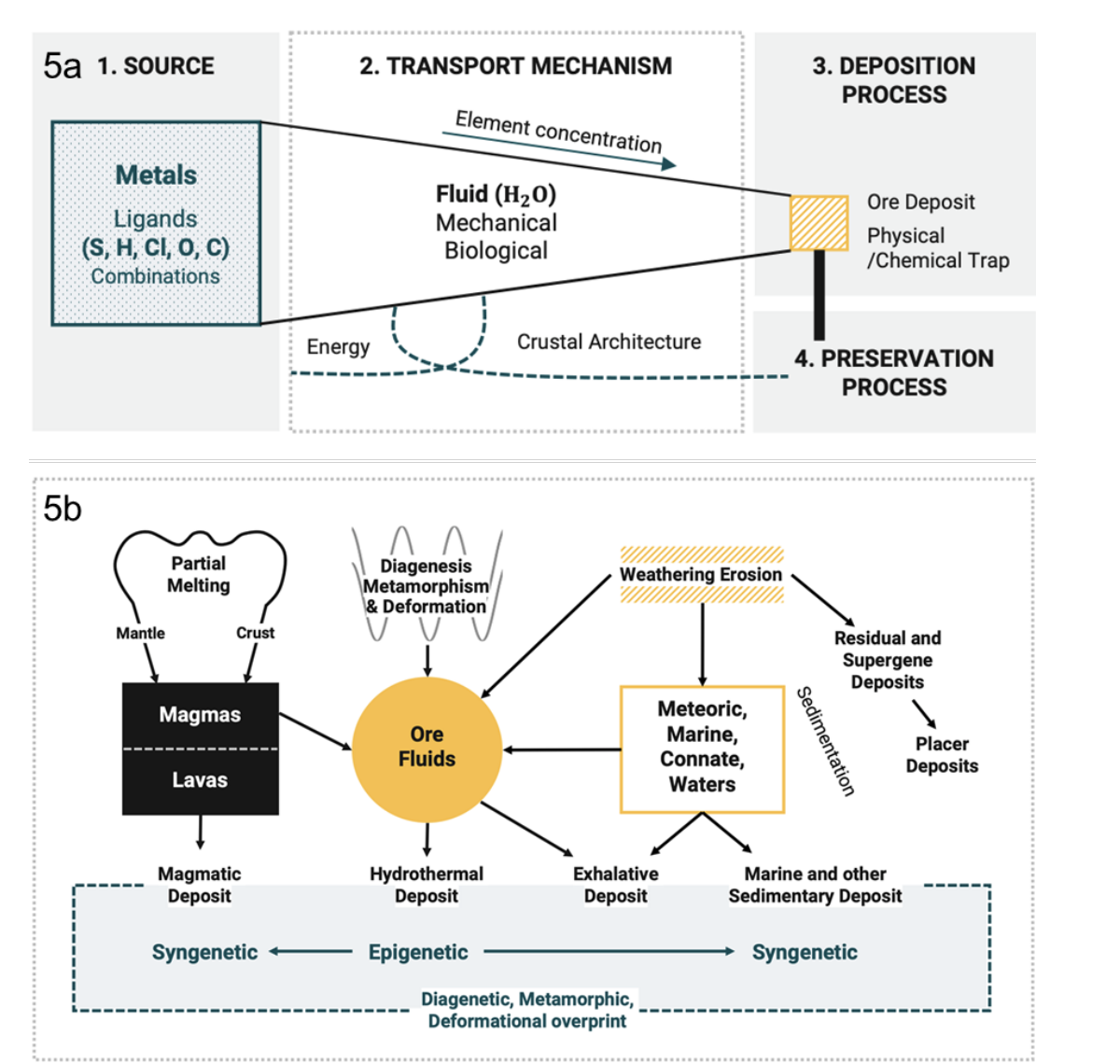
The technical developments that matter most are not the most fashionable ones. Subsurface and spatial modeling are often discussed as visualization tools, but their real function is statistical. They transform geology into a structured set of measurable proxies. In mineral systems based workflows, exploration teams decompose mineralization into components such as source, transport, trap, deposition, and preservation, then translate those components into spatial proxies derived from public and proprietary layers. When teams generate hundreds of features from magnetic intensity, gravity, structure, lithology, geochemistry, elevation, and proximity metrics, they are effectively building an underwriting feature set. This is not simply mapping occurrences. It is formalizing the causal logic of a deposit model into variables that can be scored, compared, tested, and updated. That moves decision making away from narrative dominance and toward traceable, model driven justification.
Iterative data systems are the second major shift. Traditional exploration budgets often behave like discrete bets. A program is funded, holes are drilled, results arrive, and the story is rewritten. Modern modeling workflows behave more like sequential inference. Each development step adds information that updates the model, changes the probability map, and clarifies what the next highest value data collection step should be. The core idea is that decision quality improves as the asset advances, not because risk disappears, but because the probability distribution tightens. The implication for finance is important. If a project can demonstrate that each tranche of spend is designed to reduce specific uncertainty, rather than simply to progress the narrative, then staged financing becomes cleaner. Capital can be structured around measurable information gates rather than around calendar timelines and generalized milestones.
Machine learning is relevant in this context, but only when treated honestly. Mineral exploration has structural issues that standard supervised learning does not naturally handle. Positive samples are often scarce, especially for specific deposit types in narrow regions. Negative samples are hard to define because absence of evidence is not evidence of absence. Geology is also region dependent, meaning models trained in one province do not necessarily transfer cleanly to another. Approaches like positive and unlabeled learning are valuable because they accept the reality that much of the dataset is unlabeled rather than truly negative. Oversampling and synthetic generation methods can help address class imbalance, but they introduce bias risks that must be managed through validation design, uncertainty quantification, and interpretability. What matters for capital markets is not that a model predicts a high probability zone. What matters is whether the uncertainty, bias, and failure modes are acknowledged and bounded well enough that a risk committee can sign off on the spend.
This is where interpretable AI becomes the hinge between technical work and underwriting. Regular machine learning outputs a score. Interpretable methods provide a reasoned explanation of which variables drove that score and how sensitive the result is to specific data layers. For an exploration geoscientist, interpretability helps with targeting and model refinement. For an investment committee, it changes the conversation entirely. A prospectivity map without explanation reads like another promotional artifact. A prospectivity map with defensible drivers, stability analysis, and clear linkages to geological logic becomes audit friendly. That auditability is what makes early stage assets more financeable. It allows capital providers to underwrite not only the expected upside, but also the structure of the uncertainty itself.
The underwriting consequences of these developments become clearer when the focus shifts from whether ore exists to how wide the uncertainty band remains and what can blow out the downside. In underwriting, the main variable is rarely the base case. It is variance, tail risk, and the credibility of the data environment. Geoscience advances reduce variance in several practical ways. Targeting variance declines because spatial models and remote sensing improve the efficiency of drilling decisions, lowering wasted meters and increasing the information gained per dollar. Geological model confidence increases because the argument becomes less dependent on qualitative story and more dependent on measurable proxies and converging evidence. Step risk becomes clearer because the highest value next data collection effort can be linked to specific uncertainty reduction rather than generalized program progression. Finally, the narrative becomes auditable because the drivers of a decision can be traced and challenged. That does not eliminate exploration risk. It changes the risk into something that can be structured.
Once risk becomes structured, capital markets behave differently. Capital can enter earlier because the asset becomes legible sooner, even if still pre yield. Terms can improve because risk is quantified and defensible rather than promotional and vague. Stage financing becomes more rational because tranches can be tied to information gates, model convergence, and validated proxies rather than to broad milestones that are easy to interpret loosely. This is how exploration shifts from high variance guessing to staged probability engineering. In practice, that means exploration begins to resemble a sequence of priced uncertainty reductions rather than a single binary bet on discovery.
This matters even more when viewed against the real constraints underwriters face. In mining, underwriting is burdened by nonstandard reporting, incomplete asset registers, stale risk reports, and difficulty benchmarking across accounts. It is also dominated by catastrophic exposures like tailings storage facilities, complex business interruption dependencies across power, rail, ports, and water, and weak hazard models in frontier jurisdictions where climate volatility and geotechnical uncertainty are under modeled. Geoscience modeling does not solve every category of risk, but it directly attacks the universal underwriting pain including information quality, justification, and traceability. Better data systems do not remove tailings risk, but they improve the ability to assess slope stability, hydrology, and geotechnical drivers over time. They do not remove business interruption complexity, but they improve clarity on bottlenecks and system dependencies earlier in project design. They do not eliminate jurisdictional volatility, but they create a more robust technical foundation for financing decisions that otherwise rely on broad assumptions.
The deeper point is that capital markets are constrained by legibility. Many early stage assets are not unfinanceable because the underlying resource is weak. They are unfinanceable because the information environment does not meet the standards required for disciplined underwriting. As geoscience analytics, spatial modeling, and interpretable machine learning tighten uncertainty bands earlier, the definition of what is financeable expands. That expansion is not automatic. It requires that technical workflows be translated into underwriting language, including probability distributions, sensitivity, stability, and clear gating logic. But when that translation occurs, the result is meaningful. Exploration becomes more capital efficient, not only because money is spent better, but because the cost of capital itself begins to fall as uncertainty becomes measurable, auditable, and staged.
A useful way to summarize the shift is simple. Technology improves exploration accuracy. But the larger transformation is financial. When exploration becomes explainable and iterative, capital can be structured around gates instead of hope. That is how development becomes durable through cycles, how early stage assets become investable without pretending risk is gone, and how technical progress translates into real changes in capital formation rather than remaining a purely scientific upgrade.

SKGP Strategic Partners
© 2026 SKGP Strategic Partners. All rights reserved. All proprietary frameworks, research, and materials are the intellectual property of SKGP Strategic Partners. Unauthorized use or distribution is prohibited.